Thanks to Alan Parkinson for finding this gem: "Very nice animated climate map http://www.vattenfall.com/climatemap/ Link from item in May's (2007) National Geographic, which also features fascinating article on Dharavi in India, and photo essay on US Mexico border..."
N The National Grid for Learning Cymru is funded by the Welsh Assembly Government and is managed by Curriculum Data Wales. The site has a number of excellent animations: Click here
This is a real-time 3D simulation from Prentice Hall that illustrates how topographic maps are created and used to depict changes in elevation. Students are able to sculpt mountains and valleys in real-time and see the changes to the corresponding topographic map. http://www.forgefx.com/casestudies/prenticehall/ph/topo/topo.htm
This is a real-time 3D simulation from Prentice Hall that illustrates how topographic maps are created and used to depict changes in elevation. Students are able to sculpt mountains and valleys in real-time and see the changes to the corresponding topographic map. http://www.forgefx.com/casestudies/prenticehall/ph/topo/topo.htm
Interactive animations from the Oxfam UK site. The Globe from different angles and what it looks like flattened out and journey through the earth with Holey Moley: Click for Globe Unwrapped! Click for Holey Moley!
This link starts a short animation showing debris transport by an alpine glacier and the formation of a terminal and a recessional moraine. It requires the Shockwave plugin to work properly. CLICK
Teaching Geoscience with Visualizations: Using Images, Animations, and Models Effectively Guidelines and "Visualizations" on variety of topics including glaciation, flooding, tornado formation. CLICK


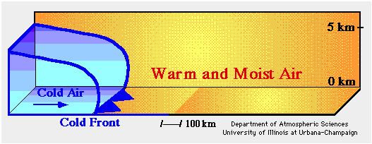
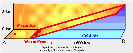